Environment
East Hemel - St Albans Council's Plan to Build Houses close to Leverstock Green
ST ALBANS DISTRICT COUNCIL LOCAL PLAN 2041
BACKGROUND
St Albans City and District Council (SADC)’s current local plan dates from 1994 and is one of the oldest in the country. Two attempts to develop a new plan in 2016 and 2020 were rejected by the Planning Inspector on grounds of legal compliance and soundness including a failure to co-operate with other authorities.
REGULATION 18 CONSULTATION
In late 2023 SADC launched a Regulation 18 consultation on a new draft Local Plan covering the period up to 2041. Based on the Government’s National Planning Framework method for calculating housing need, SADC proposed the provision of some 15,000 new houses across the St Albans district by 2041. After an allowance for future ‘windfall’ builds and permissions which had already been granted, the figure was reduced to about 11,700.
The majority of the SADC plan does not affect Leverstock Green. However, a tract of land to the north and east of the village is within the St Albans district and is owned by The Crown Estate. Since Hemel Hempstead was developed as a new town over 70 years ago, this tract of land has been earmarked for eventual use as housing. In 2018 work began on the Hemel Garden Communities (HGC) which aims to transform Hemel Hempstead and involves some 11,000 new houses and 10,000 new jobs by 2050. The HGC is a partnership comprising Dacorum Borough Council (DBC), SADC, Herts County Council (HCC), the Herts Local Enterprise Partnership, the Herts Innovation Quarter, The Crown Estate and other landowners. More information can be found on the website: https://www.hemelgardencommunities.co.uk.
The following map shows the full extent of the HGC which will involve extensive new infrastructure including roads, schools, neighbourhood centres and improvements to Junction 8 of the M1. Please note the locations of these facilities on the map are purely indicative at this stage of the project.
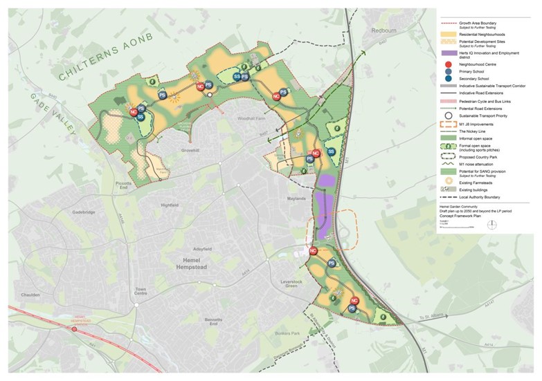
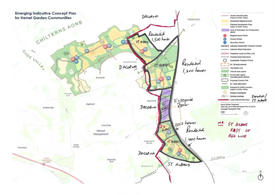
Of the 11,000 new homes, HGC are proposing to build 5,500 within the SADC area by 2050. Of these 3,100 are intended for areas to north of Maylands and 2,400 on land between Junction 8 of the M1 and the point where the A4147 crosses the M1. This latter area involves Leverstock Green and is covered in more detail on page 9 of the SADC Local Plan under H4 East Hemel Hempstead (South).
The 2016 draft of the SADC Local Plan proposed 1,000 houses would be built between Junction 8 and an imaginary line from the current south eastern extremity of the village on the A4147 to the M1. The LGVA argued against these proposals, but with affordable housing in Leverstock Green likely to be in such short supply, it was eventually acknowledged that some new development would be needed by 2030.
By the time the 2020 draft appeared, the HGC project was underway and a further 1,400 houses had been added. The LGVA argued strongly that this number of houses represented over development of the area and would encircle Leverstock Green. A planning consultant was engaged to represent our case, but the SADC plan failed the Public Examination before it reached this level of detail.
The following map shows the HGC area with the 5,500 houses proposed in the SADC draft plan marked in the areas with the black lines. The red line is the boundary between Dacorum and St Albans.
LGVA forwarded the following comments to SADC in response to the Regulation 18 consultation:
LGVA SUBMISSION TO SADC ON THE REGULATION 18 CONSULTATION OF THE LOCAL PLAN 2041
LGVA strongly supported the thrust of the submissions made by Leverstock Green residents (especially Ross Smith – reference Comment ID 54 d. 22/8/23) as well as the comments by National Highways, the Campaign for the Protection of Rural England (Hertfordshire) and Redbourn Parish Council.
Our principal objections related to:
1. The scale of SADC’s proposals in one single area rather than being more evenly distributed across the whole area of the Borough.
2. The fact that Leverstock Green is being required to bear a completely disproportionate part of the total detrimental impact of the overall development in the plan, even though the village is not within the boundary of St Albans District; and
3. The loss of a significant proportion of the green belt which protects our village environment.
LGVA recognised some additional housing was required and supported modest and proportionate development. However, we objected strongly to the sheer scale of the SADC proposals which would envelope and overwhelm Leverstock Green. Despite being part of the Hemel Hempstead urban area since the construction of the new town from the 1940s, Leverstock Green retained a distinct and proud village character and a strong sense of community. Under the proposals, Leverstock Green would nearly double in size and would lose much of the surrounding Green Belt which defined its identity. The character of the village would be changed out of all proportion, and the necessary infrastructure requirements would be unsustainable in a village environment.
- LGVA recognised the vision of HGC but was concerned there was no comprehensive infrastructure and transport plan to support the proposals. We also had misgivings that such a large-scale project involving two local authorities and multiple other agencies over such a protracted period was deliverable. We appreciated the planning was at an early stage, but the task of coordinating all aspects of the HGC would be a major challenge. The timely delivery of infrastructure and particularly roads would be essential.
- Leverstock Green was defined by its semi-rural environment with Green Belt to the east, south and southwest of the built-up area. These areas were prime agricultural land which created a green buffer around Leverstock Green and which needed to be protected wherever possible. The loss locally of such a significant amount of prime agricultural land was considered foolhardy in the current climate.
- The plan envisaged 2,400 dwellings in the East Hemel South area adjacent to Leverstock Green. This represented 18% of SADC’s total requirement. This area of Green Belt was shown as H4 on Appendix 1 (Local Plan Sites) pages 9 and 10. The area extended from J8 of the M1 to the point where the A414 and A4147 crossed the M1.
- We believed this area of 150 hectares was inadequate to accommodate over 2,000 dwellings at an acceptable level of density. Moreover, the Green Belt review recommended that only the smaller area adjacent to Junction 8 of the M1 (shown in orange on the map) should be considered for possible development. As a consequence, the number of residential units in the H4 area should be drastically reduced, probably to less than a 1,000.
- The Green Belt Review Methodology (Section 4) included an assessment of settlement area buffer zones. We suspected strongly the Green Belt Review was influenced by SADC to suit the purposes of the draft Plan. Despite Hemel Hempstead qualifying as a ‘highest order settlement’ with 400m buffer zones, the review used the presence of the M1 to conveniently justify the removal of the buffer zones from the whole of the East Hemel area. If the buffer zones had stayed in place, the number of dwellings which could accommodated in East Hemel would be reduced considerably. This would also significantly reduce the HGC ambition to build 11,000 homes. We consider the 400m buffer zone should be applied to the whole of the Site H4 East Hemel (South) (Green Belt Review Sub-Area SA165).
REGULATION 19 CONSULTATION
In October 2024 SADC brought forward the Regulation 19 consultation in the light of the new Government’s intention to revise the National Planning Policy Framework (NPPF) by introducing mandatory annual housing targets based on ‘affordability’. These new targets would take into account average houses prices in relation to average earnings in each authority area. SADC’s housing target would increase by 75% from 855 a year to 1,544. This would raise the number of houses needed by 2041 by 11,000 on top of the current target of 16,000.
SADC was hoping to avoid the new target by submitting the draft Plan to the Government before the new figures came into effect. In the meantime, SADC was already receiving ‘hostile’ planning applications which were being refused initially but subsequently granted on appeal. SADC believed the best defence against uncontrolled development was to get the new Local Plan in place as soon as possible.
As far as the planned East Hemel development was concerned, the proposals were generally unchanged from the Regulation 18 consultation in 2023. The new housing figures were 1,940 plus a further 460 after 2041. The Regulation 19 consultation was a formal and statutory process and ran for 6 weeks ending on 8 November 2024. The new consultation focused on matters of legal compliance and soundness which would be examined by the government-appointed Planning Inspector. These matters were explained on the opening page of the draft Local Plan.
LGVA engaged a planning consultant (Troy Planning and Design) to prepare a representation to SADC on the Regulation 19 in collaboration with Redbourn Parish Council. The document can be viewed via the following link: https://lgva.org.uk/lgva-representations-by-troy-pd/ or downloaded here.
In the meantime, The Crown Estate, as the landowner and developer of the East Hemel project, has employed a consultant Keith Murray Associates (KMA) to lead on Community Engagement for the development. KMA will be arranging events to obtain views from local residents and stakeholders. A second consultant (TOWN) had been engaged to develop the 80 dwellings project on Crown Estate land in Westwick Row which is included in the DBC Draft Local Plan.
EXAMINATION
Having completed the Regulation 19 consultation, SADC submitted the draft Local Plan to the Secretary of State for Housing, Communities and Local Government on 29 November for public examination. The link to the Plan is: https://stalbans.gov.uk/new-local-plan
The draft Plan along with the supporting documents and evidence base can be viewed on the SADC website at: https://www.stalbans.gov.uk/examination-library-0
Representations made to the draft Local Plan Publication in 2024 can be viewed at: https://stalbans-consult.objective.co.uk/kpse/event/42CC50BC-5FAD-4ED5-B011-F564B3AD5F24/peoplesubmissions.
The LGVA representation can be viewed under SP1, LG2, LG3, LG5 and HOU6.
Look for # 292-x. Where x is a random number
A paper copy of the draft Local Plan, Sustainability Appraisal, Statement of Participation (summarising the outcomes of the draft Local Plan consultations) and representations made at Regulation 19 is available for viewing in the Leverstock Green Library.
In December 2024, the Planning Inspectorate (PINS) appointed two Planning Inspectors to carry out the independent examination of the draft Local Plan. The Inspectors Mr Matthew Birkenshaw and Mr Thomas Bristow and also carrying out the examination of the DBC Local Plan (see the Dacorum Local Plan page on the website). Full details of the examination process and the relevant background documents can be found at: https://www.stalbans.gov.uk/st-albans-city-district-local-plan-examination
The Stage 1 hearings of the examination took place in St Albans from 29 April to 1 May 2025. The purpose of these hearings was to ensure the Plan was legally compliant and had been soundly prepared in accordance with national policy.
Most of the attendees appeared to be planning consultants representing developers whose proposals for building on the Green Belt had not been included in the draft Plan. CPRE and various parish councils and residents’ groups, including LGVA, were represented. The hearings were live streamed and are available on the SADC planning website at:
https://www.stalbans.gov.uk/hearing-sessions-0
The Stage 2 hearings will be held over four weeks commencing on Tuesday 14th October in the Civic Centre in St Albans. The first three weeks of the hearings will be held in person with the fourth week held virtually on-line.
Full details of the hearings are available at: https://www.stalbans.gov.uk/st-albans-city-district-local-plan-examination
The programme includes a joint session with Dacorum Borough Council (DBC) to examine strategic issues relating to the Hemel Garden Communities (HGC) on Tuesday 21st October 2025.
The Inspectors will be examining the proposals relating to the East Hemel South area adjacent to Leverstock Green on Wednesday 22nd October. All the hearings will be live streamed.
EAST HEMEL UPDATE BY THE CROWN ESTATE
The Crown Estate is bringing forward proposals for land to the east of Hemel Hempstead, between B487 Redbourn Road and A4147 Hemel Hempstead Road, known as ‘East Hemel’.
The Crown Estate is an independent, commercial business that manages land, property and the seabed across England, Wales and Northern Ireland. We are committed to using our resources to benefit communities, the environment and the wider economy, helping to tackle the nation’s long-term challenges in an inclusive and responsible way.
Our purpose is to deliver lasting and shared value for communities. It drives our strategy and informs everything we do. We seek to grow the value of our portfolio and return all net revenue profit to the Treasury for the benefit of the nation.
We have a new ambition to use our portfolio to deliver regeneration and housing, benefitting local economies and communities across the country. East Hemel is a flagship project for us to advance this new strategy and deliver tangible benefits to the area.
 The 975-acre East Hemel site, is allocated to deliver up to 4,000 high-quality new homes, health and community facilities, 4 new schools, new transport links and new green space that supports the natural environment, including a country park. The scale of the site, together with our purpose, means there is enormous potential to create a place which will deliver economic, social and environmental benefits for generations to come.
East Hemel forms a key part of the wider Hemel Garden Communities (HGC) programme – a long-term commitment to transform Hemel Hempstead through the delivery up to 11,000 new homes and 10,000 new jobs by 2050. The Crown Estate is working with HGC partners including Dacorum Borough Council, St Albans City & District Council, Hertfordshire County Council, Hertfordshire Futures and Hertfordshire Innovation Quarter as well as other landowners to deliver the HGC programme. More information on HGC can be found at www.hemelgardencommunities.co.uk
ENGAGING WITH LOCAL COMMUNITIES
We are committed to collaboration with local communities to ensure the East Hemel proposals are shaped by a shared understanding of local needs.
Our comprehensive engagement programme began in October 2024, when we held a stakeholder workshop and a series of public drop-in events across five different locations – Leverstock Green, Maylands, Hemel Hempstead town centre, Woodhall Farm and Redbourn.
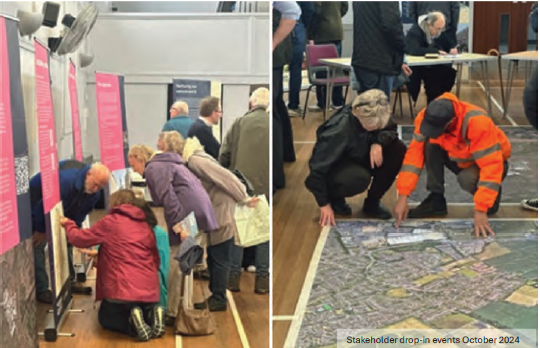
We focused these events on introducing The Crown Estate and our design team, deepening our understanding of the area, and hearing the local communities’ concerns as well as their hopes, ideas and ambitions for the site at East Hemel. Over 500 people attended the first round of events, and the valuable insights shared with us both in person and through Commonplace – a digital engagement platform – continue to feed into our vision for the site.
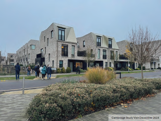
Our second stage of engagement began with a study tour in December 2024, taking Hemel residents to two new neighbourhoods on the outskirts of Cambridge. We took guided walks, spoke to residents of the new developments and learned about the successes and challenges experienced in building these new neighbourhoods. It was encouraging to hear that attendees found the visit thought-provoking and that it helped to inspire ideas that could be applied at East Hemel.
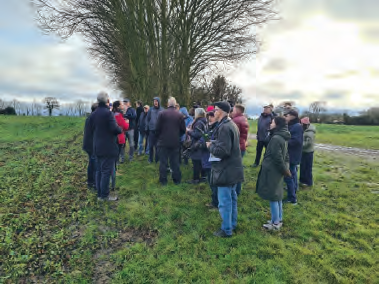 Building on the Cambridge study visit and earlier engagement, in January 2025 we held a series of community design workshops. This began with a visit to the East Hemel site to enable residents to better understand the landscape, topography and site constraints, followed by two days of in-depth design discussions which gave residents the opportunity to input on topics including transport and connectivity, sustainable urban drainage, biodiversity, housing, neighbourhood centres and stewardship.
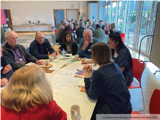
The community design workshops welcomed a range of attendees from local residents and community representatives to statutory bodies and parish council members. They provided a platform for people to discuss their priorities as well as to input directly into the spatial plans being developed for the area. To hear what attendees had to say about both the workshops and the emerging vision for East Hemel, you can watch this short video: https://shorturl.at/p8raL.
The ideas and plans produced during the community design workshops were presented to the local community through a series of public drop-in events in late February / early March. Broken down into three distinct areas – north, central and south – we shared the illustrative masterplan that residents helped to produce through the design workshops, guided by planning policy and what residents told us they wanted to see. We also shared more detailed technical information around the planning application and local plan process and themes such as transport and movement and landscape and ecology. At these events, we spoke to many residents about their priorities which included a desire to see improved transport and connectivity, a mix of housing types catering for different stages of life, concerns around noise and pollution and the provision of local facilities including schools and health services.
A SPOTLIGHT ON THE SOUTH AREA
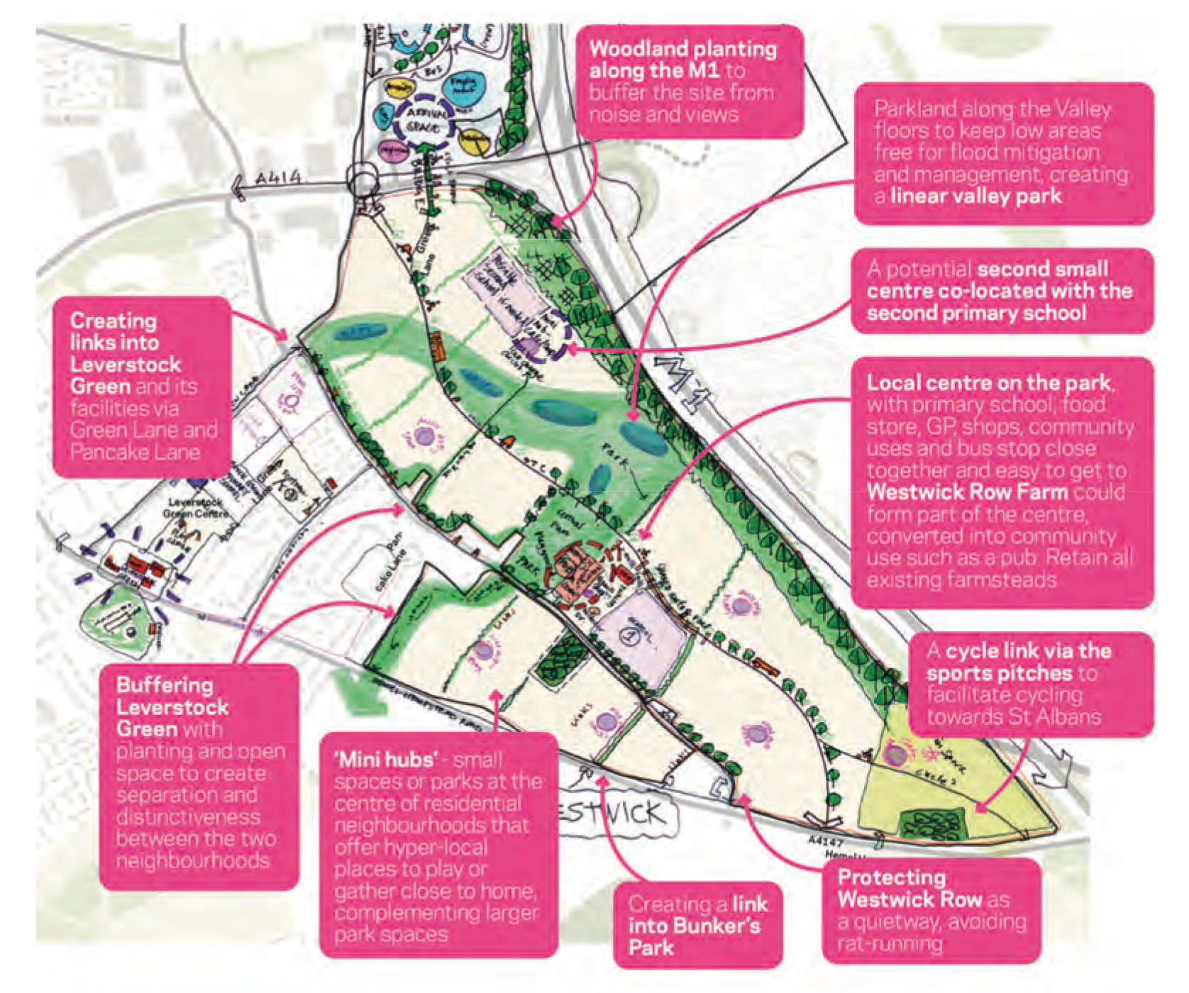
The south of the site (ie land below the A414) is allocated in SADC’s draft Local Plan for mixed-use residential development, including two primary schools and sports pitches.
Ideas raised during the workshops and subsequently presented during the events for the south area is shown in the image below:
FURTHER ENGAGEMENT
The third and final stage of engagement was held in July 2025. The engagement comprised three themed briefing sessions and four drop-in exhibitions. The website www.easthemel.co.uk has been updated with the emerging vision for the development since the previous round of engagement in January to March 2025.
This was the last opportunity to give feedback on the East Hemel Development before the submission of an Outline Planning Application in Autumn 2025 after which SADC will undertake a formal public consultation.
The Crown Estate has updated the East Hemel website to include details of the further engagement held in July 2025: https://www.easthemel.co.uk/community-engagement-stage-2
EAST HEMEL ARCHAEOLOGICAL TRENCHING WORK
Ahead of the submission of the Outline Planning Application, some archaeological trenching works will be undertaken across the site to establish whether there is any evidence of archaeological finds of significance.
Trenching works are due to start mobilising on site on 18th August in the Woodend Farm area working down to the south of the East Hemel site and will take place over a period of approximately 8 weeks. This will include the use of diggers which you may notice moving around the site.
The works will take place on weekdays and will be completed between the hours of 8am-5pm. We ask that residents do not access the fields whilst this work is being undertaken.
WESTWICK ROW DEVELOPMENT
In addition to the East Hemel site, The Crown Estate’s land at Westwick Row (located at the junction of Westwick Row and Green Lane, next to Leverstock Green Primary School) has an allocation for the development of up to 80 new homes in the Dacorum Borough Council Local Plan. Details of the Westwick Row development can be found under the Dacorum Local Plan page on the website.
